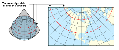
A Lambert conformal conic projection (LCC) is a conic map projection, which is often used for aeronautical charts. In essence, the projection superimposes a cone over the sphere of the Earth, with two reference parallels secant to the globe and intersecting it. This minimizes distortion from projecting a three dimensional surface to a two-dimensional surface. There is no distortion along the standard parallels, but distortion increases further from the chosen parallels. As the name indicates, maps using this projection are conformal. Lambert Conformal Conic is one of the most used map projections around the globe. There is also a variant of Lambert Conformal Conic which uses only one reference or standard parallel.
Lambert Conformal Conic Projection
To convert Lambert Conformal Conic coordinates, the following parameters have to be set: