
Vector maps
The software is shipped only with a few demo maps because it is not feasible to bundle it with all the most recent and detailed maps worldwide. To make sure almost any map can be loaded, a wide range of file formats is supported. This makes that Hydromagic can be used with the most commonly used map formats. Two types of maps are supported: vector maps and raster maps. The list below shows information on some supported raster map formats.
Supported vector maps
Vector maps are files that contain objects instead of image data, vector maps contain objects such as lines, points, polylines, polygons, and more. Sometimes these objects may also be associated with user data or a row in a data table. Because the vector objects are drawn at runtime, there is no limitation on the zoom level as with raster maps. The following vector formats are supported:
- AutoCAD DXF Drawing files;
- ESRI Shape files (SHP);
- Keyhole Markup Language files (KML);
- Microstation ISFF DGN Design (DGN) files;
- S57 Electronic Nautical Chart files;
- S63 Electronic Nautical Chart files;
- Arc/Info E00 Coverage files;
- Arc/Info Generate files;
- Atlas BNA Boundary files;
- GeoJSON map Files;
- Idrisi vector format files;
- MapInfo TAB files;
- Openstreetmap export files.
You can import a vector map into your project by right-clicking the 'Maps' folder in the 'Project Explorer' and selecting the 'Import Map...' option from the context menu, as shown in the screenshot below:
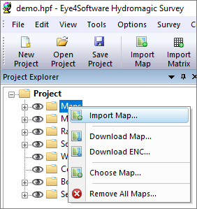
Right-click the "Maps" folder in "Project Explorer" to import a new map.
ESRI shapefiles
|
ESRI shapefiles are vector maps often used to exchange data between GIS and CAD applications. Like DXF files, it contains objects rather than image information. An ESRI shapefile consists of three parts: a .shp file, a .dbf file, and an .idx file. The database and index files are ignored by Hydromagic; it only uses the .shp file which contains the map objects. The .dbf database file is only used by GIS applications. Map calibration info is extracted from the .shp file. When loading an ESRI shape file, you have to set the projection parameters by hand. |
AutoCad DXF files
|
DXF stands for Drawing eXchange Format, and was developed by AutoDesk and is used in AutoCAD software products. It is a vector format, this means the file contains objects rather then just image information ( pixels ). AutoCAD DXF files are not designed to store geospatial information, so after loading a DXF map, you will be asked to set the projection parameters. |
MicroStation DGN files
|
DGN is a vector format used in MicroStation CAD software. The software currently only supports the ISFF (Intergraph Standard File Formats) DGN format. The newer V8 DGN format is not supported yet. In ISFF format, all objects are stored as blocks into a single file. Each MicroStation design file starts with a TCB element, containing global information on the file, such as scale, units, and extents. |