
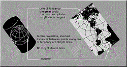
Oblique Mercator Projection
The Oblique Mercator Projection is used to show regions along a great circle other than the Equator (Mercator) or a meridian (Transverse Mercator). This kind of map can be made to show as a straight line the shortest distance between any two preselected points along the selected great circle.
Some projections that are derived from the Oblique Mercator projection are:
- Hotine Oblique Mercator projection;
- Laborde Oblique Mercator projection;
- Rosenmund (Swiss) Oblique Mercator projection;
Oblique Mercator Projection
Required Parameters
To convert Oblique Mercator coordinates, the following parameters have to be set:
- False Northing;
- False Easting;
- Latitude Of Origin;
- Central Meridian;
- Azimuth;
- Rectified Grid Angle;
- Scale Factor.