The Albers equal-area conic projection, is a map projection that uses two standard parallels to reduce some of the distortion of a projection with one standard parallel. Although neither shape nor linear scale is truly correct, the distortion of these properties is minimized in the region between the standard parallels. This projection is best suited for land masses extending in an east-to-west orientation rather than those lying north to south. It is used by the USGS for maps showing the conterminous United States (48 states) or large areas of the United States, as well as for many thematic maps.
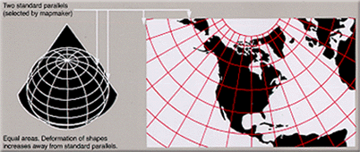
Albers Equal Area Conic Projection
To convert Albers Equal Conic Area coordinates, the following parameters have to be set: