
Export Matrix
Using Eye4Software Hydromagic, it is possible to export matrix data generated from your soundings to a third party format like a point cloud or DEM/DTM file. Hydromagic will write a projection file along with the exported data so it can easily be imported into other software.
This function can be used, for instance, to import a matrix as a point cloud into AutoCAD or to import 3D depth information into GIS or LiDAR software packages.
Currently, the following file formats are supported for matrix export:
- Arc/Info ASCII Grid Files;
- ASPRS LAS (LiDAR) Files;
- PTS (LiDAR) ASCII Files;
- XYZ Point Cloud Files;
- Hypack Matrix Files;
Additional supported export file formats may be added in the future. To export a matrix in a user-defined ASCII format, you could also use the ASCII Export function.
Exporting a matrix
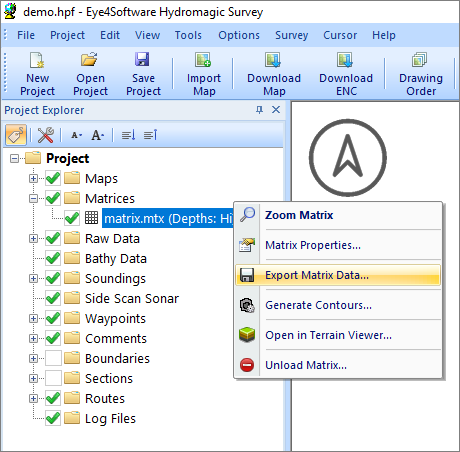
In order to export a matrix to one of the formats listed above, ensure that the "Project Explorer" is visible and expand the "Matrices" folder. Locate the matrix file you want to export and right click the file. This will display a context menu from which you select the 'Export Matrix Data...' option.
Select "Export Current View" from the matrix context menu.
Export matrix dialog
After selecting the matrix, the following dialog should appear:
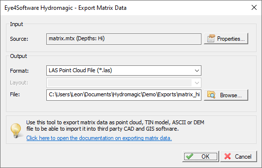
The export matrix dialog. Select the file format and file name here.
Output file format
Before selecting an output file, select the data format you wish to use to save the matrix file. Hydromagic can store point cloud or DEM data in one of the following file formats:
- LAS Point Cloud File (*.las);
- MTX Hypack Matrix File (*.mtx);
- PTS Point Cloud File (*.pts);
- XYZ Point Cloud File (*.xyz);
- ArcInfo ASCII DEM file (*.asc).
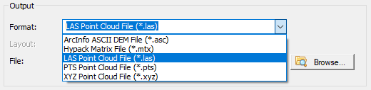
Select the preferred data format for the destination file.
Output file
First, select the output format and the file name of the data file. After selecting the data file format, use the 'Browse...' button to select the output folder and file name. If you select a file that already exists, the software will ask whether you want to overwrite it.
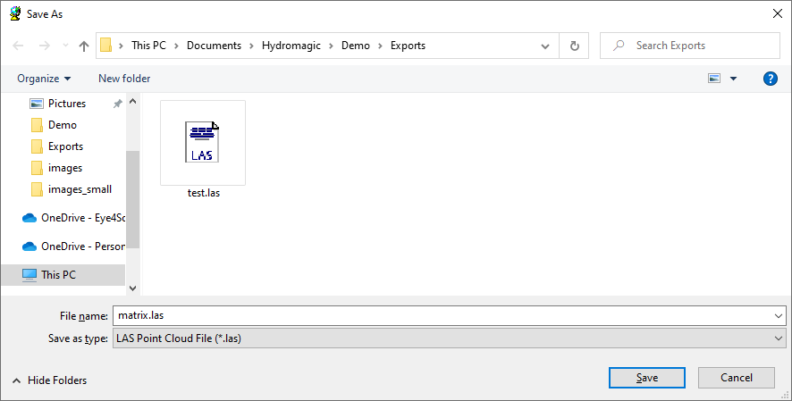
Click the "Browse..." button to select the destination folder and file name.
Projection Files
The software will also generate an ESRI WKT projection file for you. This enables the point cloud or DEMO data to be imported in most CAD or GIS software packages. The generated projection file will always have the '.prj' extension, regardless of the selected export format.
PROJCS["Amersfoort / RD New",
GEOGCS["Amersfoort",
    DATUM["Amersfoort",
        SPHEROID["Bessel 1841",6377397.155,299.1528128,
            AUTHORITY["EPSG","7004"]],
        AUTHORITY["EPSG","6289"]],
    PRIMEM["Greenwich",0,
        AUTHORITY["EPSG","8901"]],
    UNIT["degree",0.01745329251994328,
        AUTHORITY["EPSG","9122"]],
    AUTHORITY["EPSG","4289"]],
UNIT["metre",1,
    AUTHORITY["EPSG","9001"]],
PROJECTION["Oblique_Stereographic"],
PARAMETER["latitude_of_origin",52.15616055555555],
PARAMETER["central_meridian",5.38763888888889],
PARAMETER["scale_factor",0.9999079],
PARAMETER["false_easting",155000],
PARAMETER["false_northing",463000],
AUTHORITY["EPSG","28992"],
AXIS["X",EAST],
AXIS["Y",NORTH]]
Example of an ESRI WKT projection file:
Video Tutorial
The following YouTube video tutorial shows how to export your matrix data to third party software. Click below to play the video. When you like the video, please click the like button and subscribe so you will receive an update when new video tutorials on Hydromagic are uploaded.
Hydromagic allows you to export matrices in different file formats.