
Using RTK tide corrections
Using an RTK receiver in fixed mode, you have X, Y and Z coordinates with high accuracy ( < 2 cm ). Using the Z coordinate (also known as ellipsoidal height), you can calculate the current tide level in real-time, making it no longer necessary to have a tide gauge connected to the software, or to correct the sounding afterwards.
Requirements
In order to calculate tide levels in real-time, you need a RTK receiver with a valid correction signal. This correction signal can be provided by a GSM/GPRS ( NTRIP ) service provider, UHF base station or your own base station on a known location. If your RTK receiver does not have a built-in cellular modem to connect to the Internet, but your computer has an active Internet connection, you can use the 'Hydromagic NTRIP Plugin' to feed RTCM correction data into your RTK receiver. When you are surveying at a remote location without any data coverage, you can also use the "Post Processing Kinematic" method.
You also need a local geoid model. This is a file containing geoid - ellipsoid separation values for the area or country you are performing your survey.
Hydromagic ships with a few geoid models, including Belgium, the Netherlands, and North America. Additional geoid models can be downloaded free of charge from the "geoid download page". If no geoid model is available for your area, please contact support for assistance.
To perform the calculation, you need to know the exact distance between the receiving element of your RTK antenna and the water surface.
RTK receiver output
To retrieve the ellipsoidal height from your RTK receiver, it should have an NMEA0183 data output supporting either the $GPGGA or $PTNL,GGK sentence, as shown in the examples below:
$PTNL,GGK,453049.0,0,3728.455440850,N,12215.253291068,W,3,9,2.0,EHT35.7424,M*Trimble proprietary message for RTK position
$GPGGA,042629.00,3242.86076286,S,15133.15384408,E,4,12,1.1,6.573,M,26.799,M,1.0,0000*51Standard NMEA0183 sentence for GPS or RTK fix data
When the Trimble proprietary NMEA0183 message is used, the ellipsoidal height is provided directly in the sentence, in the example above it is in the ellipsoidal height (10) "EHT35.7424" field.
For standard NMEA0183, the ellipsoidal height is calculated from the M.S.L. (9) height and the geoidal separation (11) field. In this case the ellipsoidal height is calculated by using the formula below: In the example above, the ellipsoidal height is 6.573 + 26.799 = 33.372 meter.
Ellipsoidal Height = M.S.L. Height + Geoid SeparationFormula for calculating ellipsoidal height from NMEA0183 GGA or GGK sentences
Please note that the M.S.L. ( Mean Sea Level ) height value returned by the GPS is calculated using the global EGM96 geoid model, and is not accurate enough for your surveys. This is why you must provide a local geoid model instead.
RTK configuration
In order to configure Hydromagic to use RTK tides, open the preferences dialog by selecting "Preferences..." from the "Options" menu. To view the RTK configuration, click the "RTK" tab. You should see following dialog:
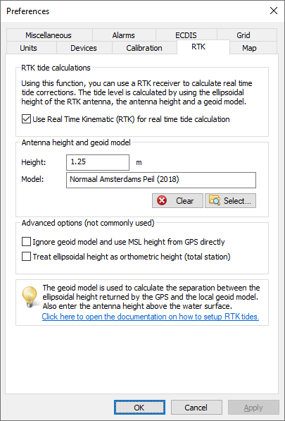
RTK settings tab in the preferences dialog.
To enable tide calculation, check the 'Use Real Time Kinematic (RTK) for real-time tide calculation' box. When checked, you can alter the other configuration options. First you have to enter the height of the antenna above the water surface. Ensure this distance is measured as accurately as possible, an error in this measurement directly translates to an error in the tide level. Secondly, select the geoid model used in your area by clicking the "Select..." button.
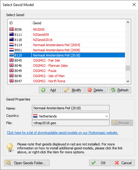
Click "Select" to choose a geoid model.
When finished configuring, just click "OK" to apply the settings.
Downloading additional geoid models
When selecting a geoid from the list, you may have noticed that some models are displayed in 'red' while others are displayed in 'black'. Geoid models that are displayed in 'black' are already installed because they were shipped with the Hydromagic installer. When you need to use a geoid model that is displayed in 'red', you have to download it first. To do so, right-click the model and select the 'Download and Install' option from the pop-up menu:
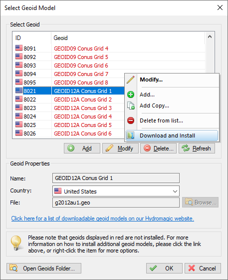
When not installed, select the "Download and Install" option.
After downloading and installing, the geoid model should be displayed in 'black'. If not, there was a problem with the download. You might want to retry another time, or download and install the geoid model manually, which is explained on the "'Geoid Download' page". When a geoid file for your area is not available on our website, you can also try to convert a third-party geoid file to Hydromagic geoid file format using the Geoid Converter utility which comes with the Hydromagic software.
Advanced Settings
Normally you do not have to use these settings. In some cases they are needed though to get a good result on the height readings. When your height measurement is far off, please try these settings to see whether they fix the error. Another cause of height measurement errors is selecting a missing geoid model. Always check whether the geoid model used is installed (see previous paragraph).
Ignore geoid model and use MSL field from GPS directly
Some newer RTK rovers have the ability to load a geoid model internally. This means that the orthometric height is already calculated by the rover. In these cases the orthometric height is returned in the MSL field of the NMEA0183 GGA sentence. If this is the case, select this option. Also use this option when you are using "Post Processing Kinematic" and the orthometric heights are returned in the PPK correction file.
Treat ellipsoidal height as orthometric height
These options should be used when a total station outputs XYZ data in a pseudo NMEA0183 GGA sentence. In this case no geoid model will be applied and the ellipsoid height field is used as orthometric height directly.
Testing RTK and geoid calculations
In order to test RTK tide calculations, connect and power on your RTK receiver, and ensure you have a valid RTK fix. The next step is to check the values in the "Navigation Data" window. If this view is not visible, you can activate it by selecting 'Navigation Data' from the 'View' menu.
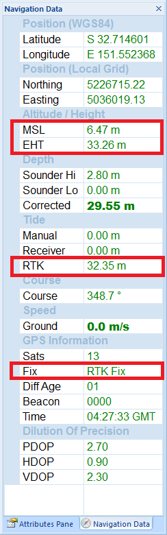
You have to check the following:
- The EHT (Ellipsoidal Height) is displayed in the data view. If missing, check the NMEA0183 configuration of your RTK receiver;
- When using the Trimble proprietary NMEA0183 sentence, the M.S.L. field can be 0.00;
- You should have an RTK fix in the GPS Information section;
- The RTK tide value is displayed in green.
Start recording
If the above conditions are met, you can start a new recording and proceed with your survey. When generating a sounding from your raw data files, you will be able to correct the tide settings if needed.