
Raw Data Tools - Latency Adjustment Tool
In Hydromagic, latency is the difference in time between taking a measurement and the time this data is received and processed by one of the Hydromagic plugins. For example, this is when a GNSS receiver calculates the position and when Hydromagic is ready to write the data record to disk.
This delay can cause position errors when it is large enough, because Hydromagic is using timestamps of incoming data to calculate the positions of soundings received between position updates. The faster the vessel during the survey, the larger these errors can become. To calculate this error, you can multiply the delay in seconds by the speed in meters per second. This means that when surveying at a speed of 5 kilometers per hour, a 100 millisecond (0.100 second) delay can cause a 14-centimeter error.
When you have the option to measure this delay, you can enter it in the plugin settings. If you discover the delay after the survey is completed, you can use the latency adjustment tool to correct it afterward.
The latency adjustment tool is part of the "Sounding Wizard" is located on the raw data processing tools page. To start the position editor, just click the "Latency..." button in the "Latency" section as shown below:
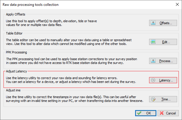
The latency adjustment tool can be found on the data correction page of the "Sounding Wizard".
Detecting latency for your GNSS receiver
Detecting latency for your GNSS receiver is the easiest. Make sure to enable the "ZDA" NMEA0183 sentence and compare the time this message is received with the time on your computer. Note that this only works if your computer is synchronized with a time server. You can use the "Show Trace" button to view the incoming NMEA0183 data in the original raw data file.
 3/18/2020|2:40:53.019 PM|$GPZDA,134053.020,18,03,2020,00,00*5E
 3/18/2020|2:40:54.010 PM|$GPGGA,134054.00,5232.58150816,N,00602.11427370,E,1,7,1.3,3.852,M,46.917,M,,*5E
 3/18/2020|2:40:54.026 PM|$GPZDA,134054.020,18,03,2020,00,00*59
 3/18/2020|2:40:55.015 PM|$GPGGA,134055.00,5232.58224474,N,00602.11427476,E,1,6,2.0,4.391,M,46.917,M,,*54
 3/18/2020|2:40:55.015 PM|$GPZDA,134055.020,18,03,2020,00,00*58
 3/18/2020|2:40:56.006 PM|$GPGGA,134056.00,5232.58224721,N,00602.11427776,E,1,6,2.0,4.392,M,46.917,M,,*54
 3/18/2020|2:40:56.022 PM|$GPZDA,134056.020,18,03,2020,00,00*5B
 3/18/2020|2:40:57.012 PM|$GPGGA,134057.00,5232.58224632,N,00602.11428281,E,1,6,2.0,4.403,M,46.917,M,,*5B
Example of some ZDA NMEA0183 sentences recorded with a Trimble GNSS receiver.
As you can see in the example above, the difference between the GNSS clock and the PC clock is up to 6 milliseconds (position error of 8 mm at 5 km/h), so you don't need to correct it. If you encounter higher values, calculate the average and use it for GNSS latency. Note that time zone differences can cause a larger error. Only compare the seconds values, as underlined in the example above!
Detecting latency for your echo sounder
The latency for an echo sounder may be more difficult to determine. The method often used is by surveying a slope in two directions (forward and backward). When you record and display this on the map, the depth values for the forward and backward directions should match when latency is set correctly. Use this tool and increment the latency value for your sounder until you get the best results. It is important to check the generated soundings for the result.
Adjusting latency values
In Hydromagic raw data files, the timestamp and latency values are stored separately. This means the current latency setting is known, and you can adjust it with the possibility to undo the setting. The latency adjustment tool allows you to set the latency for position, depth and motion data separately:
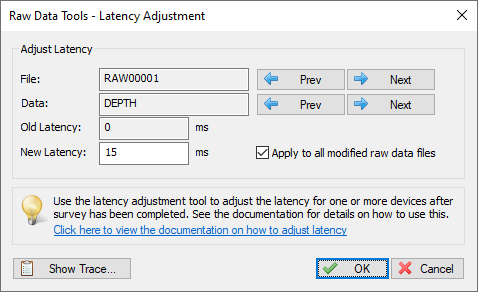
Fix latency errors with the latency adjustment tool.
Click the 'Prev' and 'Next' buttons to step through the various raw data files to see the current settings. The second pair of 'Prev' and 'Next' buttons can be used to select the raw data type (position, depth, or motion). If you want to apply the new latency setting to all raw data files, you must check the "Apply to all modified raw data" option.
In order to see the result of the correction, generate sounding(s) and check the results in the map viewer. When the result gets worse, decrease the latency, otherwise increase the latency. After changing the latency values of one or more raw data files, the changes are saved in the 'Modified' raw data folder. This does not affect your original survey data.
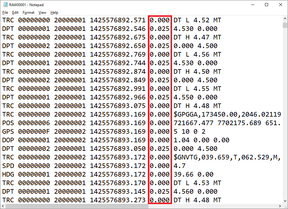
Example Hydromagic raw data file with latency for echo sounder set to 25 milliseconds.